


 Just after my Capitol Reef Hike in early October 2024, I met up with two friends to hike through The Barracks near Zion. I’ve already posted the videos for the trip, but wanted to follow-up with a written recap of the hike with a bunch of photos. For even MORE photos I’ve also added a Full Gallery as well as the track with associated POIs to my Master Map (turn on the “Other Backpacking Trips” option and zoom in as necessary). Now… on with the recap:
DAY 0:
This was the “second annual” trip with my hometown friends Corey and Tony (see the Death Hollow Eclipse video for our inaugural hike together.) They flew from Missouri to Las Vegas and then drove up to meet me at a camping spot I’d found east of Zion. We caught up around the campfire over hot dogs and beers and got excited for the adventure planned for the next few days.

fireside chat
DAY 1:
Had a leisurely morning making final adjustments to our gear/packs. Their packs weighed in at around 25 pounds each and mine was closer to 35. Not too bad for a relatively short trip.
Though we’d begin our hike outside Zion, we had to enter the park to drop our second vehicle near where we’d end up in two days. This process took longer than expected as the park entrance was so busy.

busy entrance to Zion
Before too long we were back out to the upper reaches of Meadow Creek and parked our vehicle and got ready to begin our hike. Finding our way down into the main drainage below a very brushy upper section was our first challenge.

descending into Meadow Creek
Soon we were down in and following a trickle of water down canyon. The going was a bit muddy and brushy, but not terrible. Soon we arrived at the first obstacle — the Upper Watefall. This approximately 20′ drop could possibly be downclimbed with the aid of a rope — but it looked slippery and would likely be tricky with the packs so instead we sought out the known bypass on the west side of the canyon. It was a steep route down some loose scree, but before long we were all down beneath the fall.

Upper Waterfall
After another 15 minutes or so down the canyon we came to the much larger Lower Waterfall. No rope option here so once again we looked for the bypass. It too was on the west side of the canyon, this time a fairly well-worn steep trail which descended through the brush. We had to walk back up the canyon around the bend to see the actual drop from below:

Lower Waterfall
We continued down canyon. The weather was unseasonably warm in the upper 80s, but it felt nice in the canyon as we were in the shade most of the time. After a while the water dried up and we found ourselves walking down a cobblestone-filled wash. Occasionally there would be trails to shortcut some of the benches — but some of those would leave us stuck in the deep brush cursing the decision. The cockleburs were also pretty bad here. The fall colors were starting to kick in though we were probably a few weeks too early to see the peak of this. The colorful walls high above were nice though.

Meadow Creek cliffs
After about 1-2 hours below the waterfalls the wash goes dry and walking becomes faster. Just a little farther we arrived at the junction with Mineral Gulch as the sun was already low in the sky.

Jct Meadow Creek and Mineral Gulch
This was my first time down Meadow Creek. It was nice, but I wouldn’t go out of my way to do it again. The best part about it is the convenient location for a car shuttle if doing the full Barracks as compared to parking/starting farther up along the East Virgin River. This route also allows one to walk down through the great Mineral Gulch as opposed to doing it as an up-and-back diversion (which is what I’ve done before.)
Now in Mineral Gulch we entered the first set of narrows. The sun was all but gone now and I really hated to rush through the narrows, but we were eager to get closer to the bottom where I knew we’d find water near the river. However — that plan soon changed when we came to an unexpected obstacle. In a narrow section of canyon a logjam/dryfall had formed and we were looking at what appeared to be a 20′ drop! There didn’t appear to be an easy way to climb down and I definitely didn’t want to try it with such limited light. We decided to go back up above the section of narrows and camp. Unfortunately we were running fairly low on water so it made for a somewhat uncomfortable night. In the morning we’d scout the obstacle and/or possible bypass.
DAY 2
Got up and walked down the canyon without our gear just to get another look at the obstacle to see if it was possible to climb down of if we did in fact need to find a bypass. With the morning light we realized the obstacle wasn’t as tall as we originally feared and downclimbing should be possible thanks to ample hand-holds in the 9′ drop. We went back to get all our gear and then made the climb w/o too much drama.

obstacle in Mineral Gulch
Once we were all down the obstacle we continued down the canyon happy that there were no more surprises. The next mile or so there are some truly great sections of narrows intermixed with some wider portions of canyon.

Mineral Gulch Narrows


As we neared the lower end of Mineral Gulch water began to run. It was in this section we took a diversion to see a few caves with signs of ancient inhabitants.

cave in lower Mineral Gulch

ancient rock art
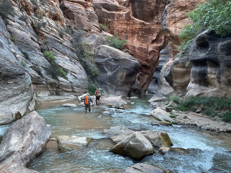
Continuing down the canyon we were soon at the East Virgin River and then headed downstream into The Barracks.

headed down East Virgin River
This next stretch is somewhat tedious as one is in and out of the river constantly. Shortcutting the bends often means fighting the brush and/or navigating steep banks. There is also the occasional deep pool and/or quicksand to contend with. We took a short break near the old corral and filled up on water from the flowing spring there. Not long after that we were to the rock art site near Rock Creek.

rock art
Continuing down canyon the walls begin to rise and become more red. There are several impressive steaked walls and undercuts.

The Barracks

Red Undercut
We continued our somewhat-leisurely pace enjoying the narrow canyon and stopped to re-fill our jugs at “Roaring Crack Spring” and took a peek into the very bottom of the scenic side canyon unofficially known as “French Canyon”.

The Barracks

“Roaring Crack Spring”

“French Canyon”
Continuing on we skipped doing the scenic diversion up Poverty Wash and soon passed “Big Red Bend”. We passed through a couple more great sections of short narrows which were somewhat dark with the fading sunlight of late afternoon in October.

The Barracks
I knew we were close to the waterfall obstacle, however just before getting there I was surprised when we were stopped by another obstacle: huge boulders separated by a deep pool and swift water.

assessing the obstacle
Over the last few years a few people had written me to say there was a new deep pool in the Barracks — but I just thought it was likely a temporary/seasonal pool. However, it seems a logjam formed and diverted the main channel around huge boulders scouring out a deep pool with no obvious bypass. When I went through in 2015 and 2018 this same spot required nothing more than wading through waist-deep calm water:

what this area USED to look like — easy peasy
Now though it was going to be much more difficult and there wasn’t an obvious route to attempt. I got into the water and found it quickly sloped down over my head. I swam through the deep pool, getting dunked by the swift water in the process. Attempting to get back was scary as swimming against the current was impossible. I had to drop into the eddy from the nearby boulder and then after getting pinballed around a few times was able to push off a wall and land upstream in the shallow water. I do NOT recommend doing this! I wish I had a photo of the looks on Corey and Tony’s faces after doing this — they definitely didn’t sign up for this level of adventure!
Looking for a better way I checked out the boulders. It might be possible for one to jump between the slanted boulders, but it would be tough with wet feet and passing packs would be tricky. Hoping for a better option, I looked for a way to climb over the gully on the right. Here I spotted a tunnel going under the upper boulder. Further exploration revealed that it would take us through to a spot we could climb down the backside of the downstream boulder. So that’s what we did.

All this scouting/scrambling took about an hour and daylight was quickly fading. We were just now atop the waterfall obstacle and thus still had to do the “normal” bypass which required another scramble down through a rockfall tunnel on the other side of the river. I’d done this twice before and thus wasn’t too worried (read more about the obstacle.) However, it took longer than expected as it seemed much tougher this time around. That could be because 1) I’d always gone up and going down had a different feel 2) It was nearly pitch black in the tunnel by this point and even with headlamps the handholds were tough to spot and 3) I hate to admit it, but my bigger/older body just isn’t as agile as it used to be! Check out the video for this section to see more about the two obstacles.
Eventually we made it down through the bypass and found a spot to camp on a nearby bench. We enjoyed our backcountry tacos with sauce the guys brought from Taco Johns in Missouri. Then we finished off our meal with some freeze-dried Crème Brûlée!
DAY 3
Woke up and headed out a bit earlier than the previous two days. I’d hoped to camp at/near the exit route the previous night, so we needed to make up some time as that was still over a mile down the canyon (and miles here are slow to come by.) This stretch of canyon is amazing so I didn’t want to rush it too much, but… the Royals were in a playoff game later in the day along with the Chiefs on MNF so we were eager to be done and celebrating our hike in Vegas while watching these games. So we set out down the amazing stretch of canyon.

Before too long we passed Misery Canyon and then it was into the narrowest section of The Barracks. I love this section.


From there it was just a few more bends down the river to our exit route. We took a quick look at the Powell Plaque and then began the scramble up and out of the inner canyon.
climbing out the exit route

climbing out the exit route
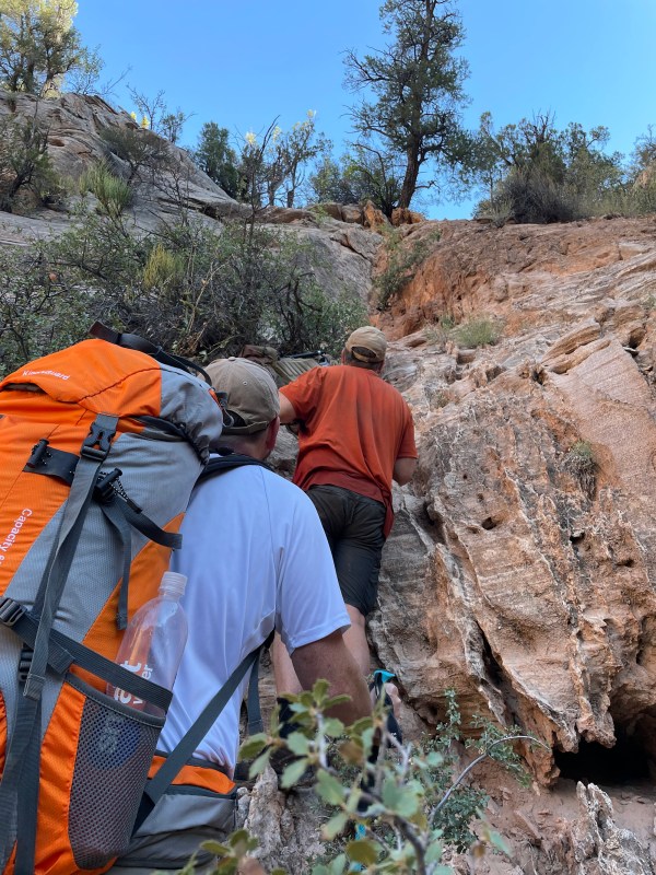
I was happy there were no more surprises in the lower canyon, however I was surprised by how brutal the climb out was! I’ve done this route twice before and it didn’t seem that hard. But again… I was going the other way (ie down!) and my body was in much better shape back then. Over the course of two miles from the river the route climbs nearly 2000′. Some of that is via true scrambles, other sections are up slickrock, and much of the trail in between is through sand. It really is a slog and we were all really exhausted by the time we were about two-thirds of the way up.

exhausted
We slowly continued climbing and before too long (though it seemed like forever) we passed the backside of Checkboard Mesa and climbed up the saddle on its west end and then descended into the eastern section of the park.

entering Zion’s East Canyon
Once we got to the road I let the guys take a break and I did the extra 1.25 miles to go retrieve my Jeep parked at the East Rim Trail parking area. After a quick celebration with some cold drinks, we retrieved the other vehicle and headed to Vegas in tandem. We were hours behind schedule unfortunately, but we still managed to get there in time to catch the end of the Chiefs win and then enjoy the evening with friends who’d been waiting for us. Difficult, but great trip!
** Trip Note: we saw ZERO other hikers while on this journey!
Don’t’ forget to check out the Full Gallery for many more photos from this trip and/or the Hike Videos for a different perspective. Also see the Hike Guide for The Barracks for more details on the hike in general.

overview map — see more detail on the interactive Master Map
Discover more from Across Utah!
Subscribe to get the latest posts sent to your email.


Love this recap! This helps give context to my severely unorganized photo/video dump!
Honored to have been part of this hike, and grateful for such an awesome guide and lifelong friend.
Great stuff!!! I love this place, but kind of out of reach for me, sadly…