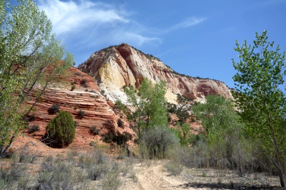
From the Across Utah 2009 Trip Report
Day 8 – The Climb to Hop Valley
Sunday, May 3rd
Cutting the back of boot yesterday seemed to help, so I repeated the step on my other boot this morning. The damage to my feet is apparent; both have big rub marks on the Achilles tendon and my right ankle is swollen.
It was a hot day to begin and the hike was through deep sand (Hanzel- not for you.) I was able to cool down though when I reached La Verkin Creek. There were nice big rapids right at the beginning.
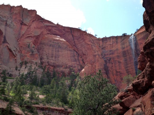
Farther up canyon I did the 1 mile side hike to see Kolob Arch. It’s the 2nd largest natural span in the world at almost 300 feet. Very nice.
Continuing up canyon I decide to do another side exploration into Beartrap Canyon. A few miles up the canyon becomes more narrow. Here I began to smell the stench of something dead. A little farther I rounded a corner I scare a big bird from the ground and it flies right over me. It was a vulture with its black/white body and red head. It had been feeding on a dead deer which lay on the bank.
Farther up the canyon got very narrow- I could nearly touch both walls with outstretched arms. The was even snow still in the bottom of much of the canyon. Then around a bend I hear a thunderous sound which makes me almost afraid to continue. But I did and saw a the creek plunging over the 20′ Beartrap Falls- awesome and the end of my side exploration.
With the sun going down I hurried back to the main trail, almost stepping on a snake along the way. Then it was a long, tough climb up into Hop Valley for my camping spot for the night.
13.2 miles (6 w/o pack)
Original Comments
-
trabera said,
May 8, 2009 at 11:20 am
Been following you every day man. I’m doing my best to keep LA under control while you’re gone.
kim_giggle said,
May 8, 2009 at 4:46 pm
hey jamal…i find your website VERY INTERESTING…hahaha oh and the whole bird thing feeding on the deer and all…EW..hahaha..oh yea..Mrs.Green told us about you cutting like the back of your hiking shoe or something and i think that was a smart move..lol..well anyways..yea..GOOD LUCK on your 9th day and all:]]…
jeremy said,
May 8, 2009 at 5:03 pm
hi. just want to let you know that it is awesome what you are doing i would love to hike across utah. cool website
Day 9 – Hop Valley To Wildcat
Got up in the morning and hiked out of Hop Valley. It was a very beautiful valley with a small braided stream following through red sand. The only down-side to the canyon is that it was recently used for grazing so there is still the effects of cows.
Climbing out of the valley I then crossed a huge sandy plateau covered with sagebrush. It was slow going during the hottest part of the day. Not after too long I was to the connector trail which climbed across the Kolob Terrace. The views down into the West Canyon were great. There were a few following creeks along the way which put an ease to my water rationing. A climb up slickrock took me to the highest part of the terrace and into a heavily forested region. I climbed higher through a meadow where there were some patches of snow and eventually reached my intended destination of camping on the edge of Wildcat Canyon.
My feet are doing better since cutting the slits in the back of the boots. I also think most of my initial blisters have now callused over and hardened my feet.
As I was setting up my tent I heard the strangest sound. It was a deep “moan” similar to an electronic generator: “Erm, Erm, Erm, Erm”. It was very rhythmic and would last about 10 seconds and then go silent for about 10 seconds. The only thing I could think it could be was a tall tree swaying in the wind. Then, several minutes later there was a huge ruckus of a huge big bird taking flight—and the sound stopped. Then, a few minutes later the sound started again, this time from a different direction, following again by the huge ruckus, then the sound again. Focusing in on an exact location now I was able to spot the bird—It was a big turkey about 40 feet away and he was not happy with me. He could see his chest pumping in and out with each of the “Erm” sounds. Then, and I tried to take a photo it did this weird hop/backflip into the air about 2 feet making the ruckus and then landing and continued its chest thumping. It repeated this action several times as I tried to scare me away I guess. I decided to let him be home he would move along. Back inside my tent, I heard a new sound—one of chicks/goslings chirping. Had I disturbed the bird’s nest? Now I felt bad. As I contemplated if I should move my camp, all the sound began to dissipate and move away. Several minutes later I heard traditional “gobble-gobbles” coming from farther down the hillside and I was happy to hear the family was re-united and seemingly happy.
18.1 miles (I think my GPS is adding too much)
Day 10 – West Rim Bound
Got up and broke camp and attempted another upload. I use a small PDA connected to a satellite phone to do my uploads and it is a very frustrating process. It only connects about one half the time and when it does it works at 9600baud—think internet back in the mid-‘90s! But, it’s nice to have a link with the real world.
I followed the Wildcat trail up towards Lava Pt. where I connected with the West Rim trail. There were some small patches of snow, but far from the 2-3 feet the ranger warned me there would be. I will save my full rant on rangers for another day, but lately it seems that more and more (not all) are uninformed and/or unhelpful when it comes to gaining insight and access into the backcountry. I know they get deluged with stupid tourists all day, but it seems like it’s come to a point that they want to protect OUR LAND so much that they discourage and/or make it difficult for anyone to gain access. The ranger in Canyonlands told me I probably couldn’t get a permit because they closed in 20 minutes and they still needed to make decorations for the Jr. Ranger Day the following morning. Luckily her supervisor stepped in and said only because I had a reservation they could oblige me. It’s a disappointing trend. (NOTE: I use the term ‘ranger’ here as a general term for anyone working in the backcountry office.)
The hike for the most of the day easily along the top of a high plateau. The views were in all directions and were amazing. The Pink Cliffs dominated the view to the northeast and the Pine Valley Mts. to the west. I stopped in at Potato Hollow and checked out the great view of Imlay Canyon. Then it was a tough climb up to top of the West Rim though the Sleepy Hollow.
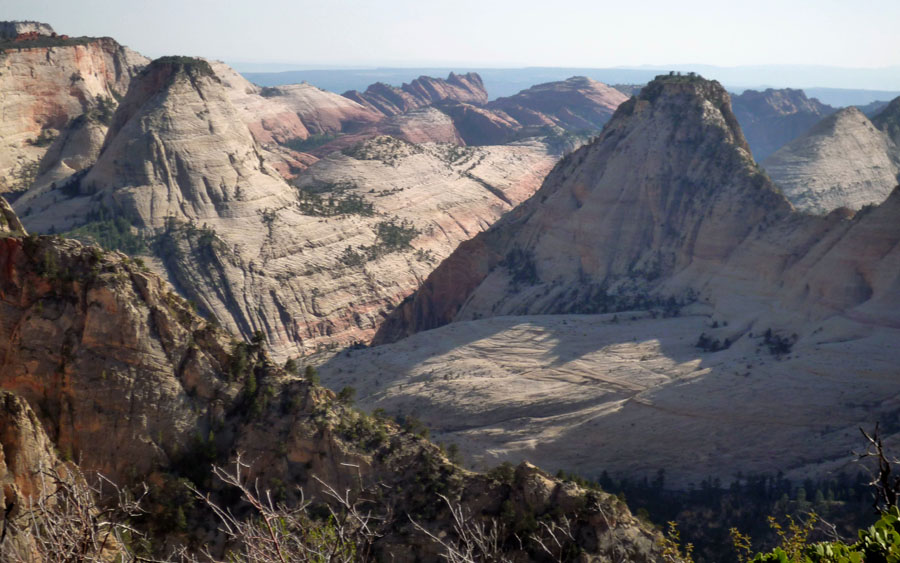
All along the next several miles the view of the Great West Canyon was incredible. I put it up there with one of the best view points I have ever seen—it really is that amazing.
Set up camp at spot #5. In the distance to the east I could see the White Cliffs east of Zion. This is where I have my next cache and is still almost 4 days away.
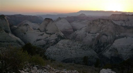
I met a lot of cool people on the trail in Zion. Several groups and I kept leap-frogging one another as we all traveled the same route through the park. Watching the sun go down over the West Rim I met a girl checking out the same view who had walked up from camp #1. She was a with a group from Utah Valley University. She invited me down for their Cinco de Mayo party—but it was a little too far away for my tired feet. Instead I celebrated solo with my re-hydrated cheese enchiladas. Ole!
12.2 Miles
Day 11 -– Hump Day
It’s hump day Wednesday and on the trail the itinerary for the day was an inverted hump—I would have to climb down off the West Rim, through Zion Canyon and then back up to the East Rim.
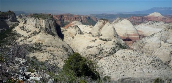
I got up early (for me) to see the early sun illuminate the West Canyon. Actually it was too early as much of the canyon was still in shadow. After I broke camp and began to hike it was fully in sunlight and beautiful. As I rounded the end of the plateau the views into Heaps and Behuniun Canyons were also great. Soon after I began the huge decent off of the West Rim. Wow—what a steep route down. The trail is basically chiseled into the side of the wall with a sheer drop of hundreds of feet off the side (Alex—you would be concerned!) The trail was plenty wide, but it was still a bit unnerving to know that a really bad trip would end in a… really bad trip.
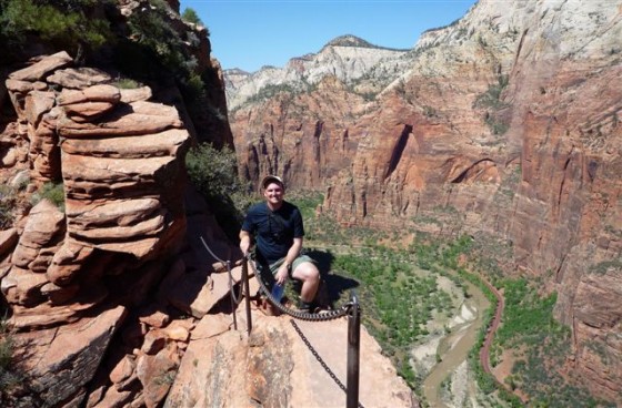
For the first day on the trail it was really hot. But, that didn’t stop me from taking the side hike up Angel’s Landing. It’s such a great route. It was also the most people I had seen in a long time.
 Just an hour later I was down to the valley floor. The Virgin River was definitely running high. I stopped in the bathrooms at the picnic area and dumped trash and rinsed off—boy was I dirty! I then took a long break before climbing out the East Rim trail waiting for the sun to go down as much as possible. I finally gave it a go around 6pm and it was still a warm climb out of the canyon. Once into Echo Canyon it cooled down. Great landscape here as well. I camped in the very upper end before the next big climb up to the rim. Beef Stew for dinner.
12.1 miles for the day
N 37.27861
W 112.92199
This entry was posted on Tuesday, May 12th, 2009 at 3:57 pm and is filed under Daily Report. You can follow any responses to this entry through the RSS 2.0 feed. Both comments and pings are currently closed.
1 Original Comment
-
BRITTANY said,
May 12, 2009 at 8:03 pm
Hey,you are crazy for stading by that rock ledge. I would never do something like that solo. I think i would seriously die without a shower ever morning. Good luck with the rest of your trip.HAVE FUN!!!!!!!!!!!!!!
Day 12 – Barracks Bound
Started the day with a big climb out of Echo Canyon onto the East Rim. The views on top were great. I could see all the way back DOWN to Angel’s Landing still visible to the west.
Once on top I made my way to Stave Spring and replenished my water supply. I also had some granola for lunch. The trail from this point on to the east entrance was pretty boring. I would not recommend the route for anyone as a primary destination. It mainly traveled through a sparsely forested mesa which has suffered a lot of fire damage. It also apparent that the route was originally designed as a 4×4 road and not a trail and thus not optimum for hiking.
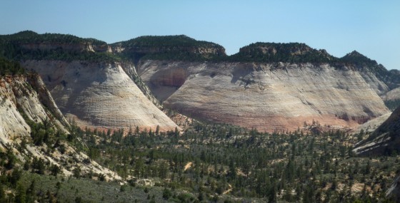
Then I crossed the main route and headed behind Checkerboard Mesa and picked up the route to the Barracks area south of Zion. The climb up and over was a little rougher than I had expected with the big pack, but it wasn’t too bad. I also met a group hiking out that said the water levels in the Barracks were ok alleviating my biggest fear of high water during spring run-off.
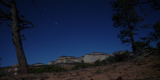
Once behind Checkerboad Mesa the terrain opened up into a beautiful slickrock country. I made my way across and up to a high knol which sets just outside the national park and camped for the night. Hearing a frog nearby, I investigated and find found a series of potholes which helped supply extra water for camp. With a near full moon at night, I took some pictures of the cool landscape by moonlight. I hope they come out.
16.2 miles
N. 37.19160
W. 112. 86301
Day 13 – The Barracks
Today was a day of drama and dominated by three very memorable events.
After breaking camp I made my way down into the canyon via the very steep decent route. It’s a popular route and well marked, but that didn’t make it any easier for the solo backpacker. The last several hundred feet required carefully climbing down a series of boulders 10 feet at a time. It was a slow process with a big pack—but I never had to remove my pack so it wasn’t THAT bad.
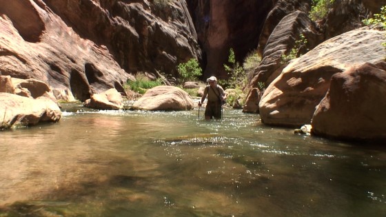
Once down in the bottom it was paradise. The Barracks is a extremely narrow canyon carved by the East Virgin River. The river was running crystal clear and about knee-deep in most places. The canyon alternated from narrow portions about 40 feet wide with lush greenery on the banks, to extremely narrow spots about 15 feet wide which are dark as a cave as the sun never makes it to the canyon floor. There are very few spots one can climb in and out of the canyon. In summary—the portion of the canyon is just amazing—and somewhat of a secret and probably doesn’t get 1% of the visitation as The Narrows.
 I made my way down canyon first to see if I could make it to Barrier Falls. I was stopped by one deep pool where I decided to leave all my gear and jump in. It was quite a swim—but the water came up to my chest. I little farther down there was a huge rockfall and more rapids. I don’t think this was Barrier Falls—but I decided to turn around at this point as it would take too much effort to get past this obstacle.
Back up canyon I was exploring the brush along the river bank. There is a plaque in honor of John Wesley Powell here in the canyon and I wanted to check it out. I’ve heard it’s somewhat hidden in the brush so I’m in a bit of a bushwack when I got snagged in the brush. I pulled with all my might and could not break free. I turned around to see what the problem is an just as I do a huge branch breaks free and hits me square in the eye. I instantly droped to the ground in extreme pain. I seriously thought I might have a bad puncture wound and I feel my eye for blood—but there is none. I stay there several minutes before even attempting to see out of the eye, but when I do it’s extremely blurry, but I can see. I make my way back out into the clear and put a cold bandana on it for a while. I try hiking with the eye covered—but it’s too difficult. After a while, the eye is ok to see—though it’s still really fuzzy. I give up on Powell’s Plaque and trudge upstream hoping the eye will recover with time.
As I go upstream I continue to be amazed with the beauty of the scenery. It saddens me though that my eye is now making it harder to enjoy the beauty. Frequently as I round a corner I will scare away a duck or two which will be floating in the stream. They quack and fly away to fly a new spot to lounge. As I round one corner I hear a huge ruckus. Though I didn’t see it, I guessed it must have been a whole flock of ducks.
Just a little farther up canyon I reached the spot I had been dreading—the rock fall and logjam which serves as the only real obstacle in the canyon. But, just a begin to size it up I hear a huge clamoring to my left and see rocks falling down from above.
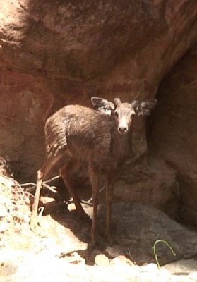 There was a deer which I had inadvertently cornered and it was trying to climb up an insanely steep crack in the wall. It was panicked, but was already about 12 feet above me and trying to climb higher up the impossible cliff. It got to about 20 feet high and then slid back down to its previous spot. Then it took another lunge up the face and this time it fell forward. It was one of the most awful sights I’ve ever seen; the deer fell over the edge toward me upside down in a complete freefall to the canyon below. Where it hit was behind a large boulder which obscured it from my view. I cautiously walked around just sick to my stomach knowing I was going to see a dead deer—or worst one crippled and writhing in pain. It was upsetting that I had caused the panicked behavior of the deer. To my surprise, I rounded the boulder and there was a wet, young buck standing on all fours shivering. I was so happy—but the drama wasn’t over. I tried to talk to the deer calmly by backing away, but it was hard to get much separation. The deer began to climb the wall again—but then quickly gave up and just turned back to me. I pleaded with it to go down as I tried to position myself up canyon as much as possible. FINALLY—the deer took the bait. He slowly took several steps toward me to free himself from the tiny cove he was trapped in. Then it dashed to the left and down canyon away from my as fast as he could. As he splashed through the water it appeared as if he would be just fine.
Whew– but now I still have my own escape to pull off as I am still at the bottom of the huge rockfall/logjam/waterfall.
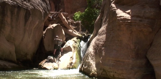
The obstacle is not to be taken lightly by anyone. The current conditions of logs and debris trapped on top of the existing rockfall makes this one tricky spot. Even for day hikers with a buddy one should take caution. For a solo backpacker—it requires extreme caution and I would NOT recommend attempting.
The first step was for me to wade though belly-deep water carrying my pack above my head. Once I reached the bottom boulder I had to push my pack on top and then climb out of the water onto the same rock. From here I needed to hoist the pack and then myself up to the mid-level of the logjam. All of this action must take place on a slippery rock right next to the roaring waterfall. I used a 30’ rope to secure the pack and lift it from spot to spot. The last step is to actually climb the logs and debris which hang over the waterfall another 8 feet up to the top of the logjam. A fall here could be fatal as one would likely get trapped in the bottom of the waterfall, where with the rush of the water, it would be hard to escape. I slowly made my way up the logjam making sure each hold was secure. I finally got to a point where I could push my bag over the top. I was relived, but still needed to get myself over the top. As I climbed up the very last bit, no exaggeration, the limb my foot was on broke and fell away. Luckily, the majority of my weight was now on the precipice of the logjam and I was able to pull myself up using my arms. Over the top, I lay there in the sand relieved! But… then my eye starting throbbing presumably from the stress of the situation. I stayed there for a while and finally the pain subsided.
 For the rest of the day I continued up the canyon w/o as much drama. The only problem continued to be my eye. Every 45 minutes or so it would begin throbbing and I would immediately become very dizzy and have to set down for a while to let it recover. Usually after 5 or 10 minutes it was fine and I would repeat the process. I camped by the creek several miles upriver hoping a night of sleep will do my eye good.
Despite the drama—it was still a great day. Moral to the story—never let a stick in the eye get you down.
Out of dinner supplies, so for dinner I had re-hydrated scrambled eggs and bacon.
10.7 miles
6 Original Comments
-
Daniel said,
May 13, 2009 at 2:40 pm
Hey Jamal, your 600mi solo hike would be outstanding enough without your adding 20mi of wading, 2mi of swimming and 3000ft of vertical technical climbing to it! Please be careful .. steep slot canyons and large backpacks are a dangerous combination.
SilentFlower said,
May 14, 2009 at 2:26 pm
Bonjour ^_^ my name is Corina, I’m one of Mrs. Green’s students. (4A) Its cool that you helped that deer! Save the animals!! Hahaha
saruiz said,
May 14, 2009 at 2:57 pm
Hi Jamal — Hey, sounds pretty exciting, so far! What a day! Sorry I haven’t sent a note sooner, but I have been following your adventures all along. Great stuff! Can’t wait to see more pix.
Are you all skinny and scruffy at this point?
Stay safe & keep enjoying! What a great experience!
sione_orange@yahoo.com said,
May 14, 2009 at 8:39 pm
Hey, just wanna say that your probably an inspiration to kids all over the word ( or in this case your moms class) im in your moms class by the way and i hope you good luck with your trip, hope you come back so you can tell us about the trip, that really sucks about the food and soda stuff. well have a good time and hope you make it.
kim_giggle said,
May 14, 2009 at 9:36 pm
DANG!! YOUR LUCKY AS HECK JAMAL!!…I like the pictures..those pictures are pretty…lol
i bet the water or river or whatever it is felt pretty good cause since its gettin
close to summer and all…and it’s probably hot around where you’re at..lol
L_Aun said,
May 19, 2009 at 4:26 pm
Hey Jamal! My name’s Lisa, and your mom’s been talking about your hiking adventure and i thought it would be cool to leave you a comment about your adventures! I think that it’s pretty cool that your doing this just for fun! And your kind of an inspiration to future hikers! Especially considering all the obstacles you have to face (the hot, the cold, the water, etc…) so I just wanted to say good luck and hope you can make it all the way in 49 days!!! 😀
Day 14 – The Junction
Got up in the morning and was happy that my eye was feeling better. However, a quick vision inspection revealed that my previously perfect-vision left eye now was very fuzzy for anything in the distance. I will keep an eye on it. 🙂
I made my way along the never-ending canyon that is the upper Barracks. The canyon now is composed of red rock and quite pretty, unfortunately the serene scene is spoiled by that fact that cows are allowed to graze in the canyon later in the year and they have really mucked up the place. A little farther up, the route escapes the red canyon and is walled in by impressive section of the White Cliffs—which are a colorful swirl of red, orange, yellow and of course white. I followed an ATV route and then gravel road for the last few miles toward the small town of Mount Carmel Jct. Just south of the town is where I met up with my parents for our planned rendezvous. It was great to see them. We found a great camping spot nearby and cooked a huge dinner—steak, salmon, hot dogs, fresh fruit and veggies. It was perfect—and probably more calories than I have had in the last week! I even had a soda (or five!)
6.5 miles
