


![]()
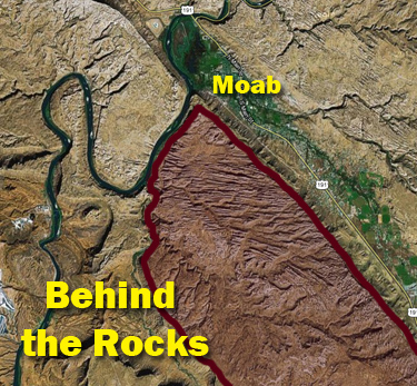
Behind the Rocks is a great region of fins, arches, spires and canyons just south of Moab. The area provides several options for day-hikes, short backpacking trips or even an alternate route for Hayduke Trail hikers looking to escape the official route along the paved road.
This guide describes a route for those traveling from north to south (ie from near Moab to Kane Springs Canyon.) Please note that the associated map for this guide is rotated 90-degrees clockwise for optimal on-screen appearance. The route described is approximately 20 miles one-way. However, if one isn’t a thru-hiker or doesn’t have a car shuttle, it’s approximately 9 miles more via road to close the loop. Much of this additional mileage could be skipped if taking an alternate route to close the loop as mentioned below.
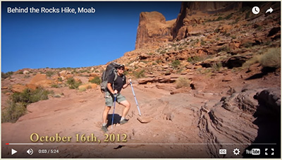
RELATED: also available are the Behind the Rocks Video (2012) and the Through Arches and Behind the Rocks 2017 Trip Report.
One will see the Moab Rim Trailhead on the left just about 1.5 miles after leaving Moab on Kane Creek Blvd. This is where to begin and one should find ample parking and pit toilets. The route doubles-back toward Moab and quickly climbs the cliffs through the sandstone. One is likely to share this section of the trail with day-hikers, 4-wheelers and mountain bikers. Either way the view back to the Colorado below is nice (and be sure to spot the arch high on the opposite wall.)

At the top of the slickrock and as the route bends back to the south, be sure to walk 100 yards out to take in the magnificent view of Moab and the La Sal Mountains behind. Private property keeps one from descending right into the town:

Moab Overlook
The route continues away from town and through a gap in the rocks. Stay right at the split in the trail not too much farther ahead. After the path climbs over a slickrock high-point, leave the 4×4 route and head toward the jumble of rocks/fins to the south. Generally head down the gully through the fins until it will be necessary to scramble left up and through a corridor to the south. This is a tricky section — be sure to study the map to have a general sense of direction through this area. There is likely to be quite a bit of up and down, back and forth, trial and error in order to make the necessary progress.

After some lateral movement, head SW through a relatively open area to find what has been dubbed the ‘Kidney Bean’ Mesa (based on its appearance on a topo map.) This spot is right above Pool Arch in the heart of the rocks and has an incredible view of the fins to the east/southeast:

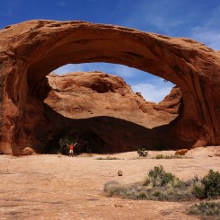
Pool Arch can soon be seen from above. Canyoneers sometimes rappel down through the arch and on down the canyon on a route known as Rock of Ages. As a hiker you can hike down a way around the arch to the left (your eventual direction), or up to the right and then down and to get directly below the arch. Note that is is possible to reverse the course that canyoneers take to get to this point to return to lower Pritchett Canyon and close the loop if desired*. Otherwise…

Continue up between the fins to the east/southeast. It’s not an easy route, but it always goes through albeit with a lot more of the up and down, back and forth similar to the previous set of fins — now with some brush to make it even more complicated.

Eventually one will make it to what I dubbed “Spire Pass” — so named for the prominent spire towering above the ascent route. In this photo behind me is the long corridor just described. Pool Arch would be way back down there in the distance.

From the pass make one’s way down the next gully to a small side-passage on the left. If you go too far (and you likely will), the route will abruptly end at a huge chasm:

Turn around and go back less than 5 minutes and look for the V cut in the fin now on the right. One can get through here and then navigate up around the head of the next canyon. At a few spots it appears as if the route is ledged out, but each time luckily there is one small ramp providing access up/down. **The Solstice Snake and other great petroglyphs are in this general area if one has time to explore.
Head back down this canyon which is wider than the previous corridors. There are likely to even be some social trails. Lower down are some cool balanced boulders to check out.

After passing a side canyon on the right, one will the soon pick up an old Jeep road. Look for an arch high on the ridge to the left just before a junction with another canyon branch coming in from that direction. Head down canyon to the right. Look below the road in the wash to spot Troll Bridge:

Just a little bit farther and one will intersect the much-more-traveled Pritchett Canyon Jeep Road. Here one can turn down canyon and close an abbreviated loop*, or turn left and travel up canyon and continue the adventure.
NOTE: if one returns to the main road via Pritchett Canyon (or the Rock of Ages route), be aware that the very bottom of canyon crosses private property and the owner requests all hikers pay a $2 use fee.
Traveling up Pritchett Canyon is much easier than previous travel as one is back on a well-established path. Depending on the season, one might find pools of water in the drainage alongside the road. Besides checking out the crazy 4-wheel route, there are many other cool sights to see. The first one is Ostrich Rock (Pritchett Arch partially seen in the bg):

Then Window Arch appears along the bottom of the White Knuckle Hill section of the Jeep route:

Continue following the Jeep road and once at the top of the hill the route goes back down and around the corner and heads SW again where one passes this cool spire along the road. It reminded me of the statues from Easter Island:

Not far past the spire there is a spur road/hike on the right to Pritchett Natural Bridge (which is really an arch). The short hike passes two other arches a (Cummings and Wigwam) and is definitely worth it:

NOTE: I’ve been told it’s possible for hikers to go directly from Window Arch to Pritchett Bridge via an unofficial/unmarked trail, but I have not personally done it.
Back on the main route, soon the road enters Hunters Canyon before crossing the wash and continuing up the other side. While in the wash, one can walk a short distance down canyon to check out the dryfall which blocks passage to the lower canyon:

Below one can hear the dripping of water from the spring and see the area is robust with life. Unfortunately there is no easy way down to this perennial water source. A route down on the south side requires scaling two 10-12′ ledges. One is likely to find a log and/or rocks stacked to help with obstacles. It’s a formidable challenge for a solo backpacker, but those with buddies are likely to have an easier go of it. If you make it down I’ve heard it’s possible (though brushy) to hike the length of the canyon down to connect back to the road.
From here there is another option to close the loop before going the extra distance to Kane Spring Canyon. To do so, follow the bike/hike route along the right side of the Hunters Canyon which eventually connects back to the main road. Make sure to see the small ruin on the spur hike as noted on the map. Otherwise…
Continuing south and away from the Hunters Canyon drainage, the main route follows the gravel road toward the rim of Kane Spring Canyon. Several times less-used roads will split to the left, but stay to the right and along the edge of a moderate canyon on your right. The views back toward the heart of the rocks with the La Sal Mountains behind are great:

Before one gets to the edge of the plateau you will come to an ‘T’ intersection in the road. Most traffic here will go left, but to complete this route and climb off the mesa, go to the right. NOTE: thru-hikers may wish to go left to the Trough Springs Canyon and Over Hatch Mesa short-cut if headed to Canyonlands. NOTE #2: even if doing this route, one may wish to go off-road straight ahead to see the incredible views of Kane Springs Canyon before doubling-back to the road.

Following the road (or canyon rim) to the northwest, eventually one will find a way to to a weakness where it’s possible to descend. This route is frequently used as a portage by mountain bikers. The upper portion may appear rough, but it’s not that bad. Then it connects to an old mining road which makes for a quick route to the valley floor below right near the unique Happy Turk Hoodoo (aka Devils Golf Ball).

If walking (or driving) the road back to the Moab Rim Trailhead, be sure to check out several cool panels of petroglyphs along the way. Many are somewhat damaged, but still worth a quick look. The best to check out are ‘The Birthing Scene‘ and those at ‘Moon Flower Canyon‘, but a few others are there to reward a keen eye as well.

Gallery:


-

- Moab Overlook


-

- Sun up on camp above Pool Arch
-

- Pool arch
-

- at “Spire Pass”
-

- Solstice Snake | Behind the Rocks ⮞⮞⮞
-

- balanced boulders
-

- Troll Bridge
-

- Pritchett Canyon
-

- Window Arch | Behind the Rocks ⮞⮞⮞
-

- dead-end canyon
-

- Sitting Ostrich Rock
-

- solitary spire
-
- Pritchett “really-an-arch” Natural Bridge
-

- Pritchett “really-an-arch” Natural Bridge
-

- view to lower Hunters Canyon
-

- scramble route down into Lower Hunters Canyon
-

- scramble route up from Lower Hunters Canyon
-

- the drop into Lower Hunters Canyon
-
- Hunters Arch seen from north rim route
-

- camp in western Behind the Rocks
-

- View to La Sals | Behind the Rocks ⮞⮞⮞
-

- along the rim of Kane Springs Canyon | Behind the Rocks ⮞⮞⮞
-

- Descent to Kane Springs Canyon Road


-

- Moon Flower Canyon Petroglyps
Also see:
Discover more from Across Utah!
Subscribe to get the latest posts sent to your email.


Very informative and beautiful pictures!!!