


Headed south on the Moody Road
In mid-May I set out on my second loop hike in southern Utah in 2014. Yep, that means… no extended thru-hike this spring. 🙁 The goal this time was to explore Escalante’s “Lower East Side” including the Moody Canyons and the southern portion of the Waterpocket Fold.
FYI: a Hi-res Gallery and Hike Video also available! And the Hike Map too.
.
I had such an ambitious plan: up from the Moody Canyons via the “Sheephunter” route detailed by guidebook author Steve Allen and then south along the Fold maybe exploring the middle of Stevens Canyon before heading over the Baker Trail and up Halls Creek via the Narrows and then back over the Red Slide to the Moody region to complete the loop.
Yeah… that didn’t happen.
Once I failed to get up the Sheephunter route solo, plans were improvised. I tempered my ambition and instead enjoyed a slower pace of exploring a different section of the Circle Cliffs/Fold.
For those who just want the recap: this is remote, beautiful area where it’s likely you will see few other people (I saw ZERO in 2 days of driving and 5 days of hiking.) BUT, unless isolation is your top priority, I don’t really recommend this hike. The area includes colorful Chinle hills, petrified wood, entrenched canyons with streaked walls, towering Wingate cliffs and sandstone domes. However, it’s not really the best example of ANY of these features in the region and the rugged/remote terrain is much more work.
So, if that recap didn’t completely turn you off… read on for the full trip report!
I drove east along the Burr Trail through a late-day rain shower and enjoyed a great view of a rainbow at the overlook of Long Canyon.

Rainbow over Long Canyon
Just before Capitol Reef I headed south on the east side Wolverine Loop Road and then onto the Moody Canyons Road. The gravel/dirt roads were fine despite the recent storm. I stopped at the waterworks near Colt Mesa and was pleased to see it still running. This is such a great water source for extended hikes through an otherwise dry region. Just over an hour after leaving the pavement I neared the end of Middle Moody Road. Seeing a truck already at the TH, I went back and car camped east of the colorful outcrop of Chinle rock known as Purple Hills. Note: there are NOT a lot of spots to camp along the lower Moody Road, luckily it’s not that popular.

The Purple Hills
The next day I walked back to the TH and then down into Middle Moody Canyon. Access is via a boulder-filled gully immediately SE of the parking area.

Within 10 minutes I was to the bottom of the entreched canyon. I headed downstream as the canyon walls closed in somewhat with huge boulders littering the streambed. I encountered intermittent water throughout this section, though it’s likely not there year-round.

Dead Cow
Soon the canyon opens up and I could see the higher red walls of Wingate sandstone. I also saw a dead cow. 🙁
Walking was pretty easy down the wash and soon I was at the junction with main Moody Canyon. There was a fairly substantial outbreak of surface water just below the junction.

Jct. Moody and Middle Moody Canyons
Continuing down canyon the walls rose higher and higher. Chunks of red rock have collapsed blocking the main path many times, but they never create any type of real barrier to progress.
Taking a break farther down canyon I was surprised to hear the Escalante River ahead in the distance. That it was audible from around a bend made me worry that it might be running really high. BUT… when I got up and started walking again I immediately saw… the Escalante! It was NOT still around a bend, it was less than 30 yards away hidden by a depression and some brush and not running high at all.

Escalante River just south of Moody Canyon
I headed down river fighting the brush along the bank. It was a pain so I gave up and just got in the river. It was a much easier go just walking right down the middle of the knee-deep Escalante. There were a few tricky spots of slick rocks or deep sand, but all-in-all it was a nice walk. Soon I was able to get back up on the shore and from that point it was easy to walk along the river all the way down to East Moody Canyon. Though there was still an hour or two of daylight left in the day, I went ahead and made camp here because it was such a great spot.

Camp near bottom of East Moody Canyon
Well… great except for the gnats that is! Ug — they were awful this year. The black gnats and the no-see-ums were both out in force and DEET didn’t seem to help much. It was definitely the major downer of this trip.

Streaked Walls of East Moody
The next day I headed up East Moody Canyon. The first several bends are spectacular with a small running stream, big alcoves and classic-Escalante high walls streaked with desert varnish. Going was again slow picking my way through the boulders — even more so now with water and mud — but the section wasn’t technically difficult in the least.

Lower bend of East Moody Canyon
About two miles up canyon East Moody begins to open up and dry out. Colorful mudhills return with the red sandstone forming the higher walls. Large chunks of petrified wood are a frequent sight in the wash as were blooms this spring. There were a few minor outbreaks of water, but otherwise this section is really dry and doesn’t have a lot of shade — not a place you’d want to be in the real heat of summer.
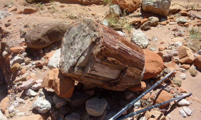
Petrified wood in East Moody Canyon
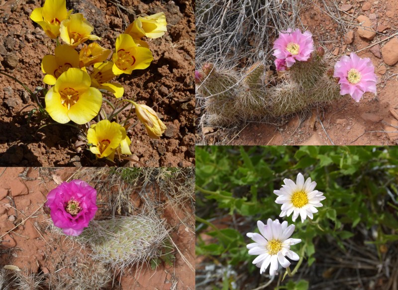
Spring blooms in the desert
After arriving to the branch of the branch that I would take up to the “Sheephunter” route, I was very happy to find a nice source of running water. I filled up and started climbing up the big boulders in the unmarked side drainage.

Climbing up to the Sheephunter Route
It was a lot of work, but again nothing technical. Soon I decided to leave the main drainage and instead tackled the slopes of dirt and rock. Still quite a bit of work, but it was better in my opinion. I scared off a momma sheep and kid along the way. Seems like they would know to avoid the “Sheephunter” route!

Near the top I re-entered the main drainage just as the upper domes pinched together. I could see the sandstone wall ahead that Allen describes as the crux of the route. BUT… before I could get to that point I was stopped in my tracks by a minor dryfall which had a scoured out, slanted floor below. Though it was only about 9′ tall, it was overhung in a way that made it really awkward to climb. On the side someone had stacked some wobbly rocks to serve as an assist. I actually worked on the stack for about 30 minutes making it about twice as high and much more stable. Check out my improved “step”:

Obstacle before the crux of the Sheephunter Route
As you can probably tell from the picture, I still wasn’t pleased with the prospects. Even with the assist it was going to be a very awkward move to get up on top. Undecided and late in day, I decided to make camp just back a short way below the obstacle.
The next day I opted to ditch my ambitious plan. The obstacle really wasn’t that bad and I think I could have gotten past it (especially with a spotter), but I’m not sure I could have reversed the route safely if needed and the consequences of a bad fall were too great. I was hiking w/o a SAT phone or a SPOT on this trip and nobody would “miss” me for another week. So, with that in mind, I decided to turn around and instead explore another route up about four miles farther north on the map.
I couldn’t really size up what Allen considers the true crux of the route, but for those interested here’s a zoomed look at it from below the dryfall.

Crux of Sheephunter Route
Headed back down the steep slopes was still no easy task, but definitely quicker than going up!

Looking down from near the top of the Sheephunter Route
Once back at the bottom I filled up on water and then headed down the dry upper portion of East Moody. About the mid-point of the canyon there is a north branch which actually leads to a pass connecting East Moody with Middle Moody. This is a documented route for those wanting to make a loop out of the Moody Canyons.

Big petrified wood in north branch of East Moody Canyon
This northern branch was slow walking as it wound though the mudhills. Several times there were minor rockfalls/mudslides which required short bypasses. Though not a very fun route, this section did include the best petrified wood of the whole area. Look in the side gullies to see the best of the best.
Near the top the canyon opens up as one needs to hike over the pass. Just before leaving the wash there was actually a little bit of water. After topping off I headed up and over the pass. It was fun and rewarded with great views to the north.

Looking to Deer Point from pass to connecting Middle and East Moody Canyons
Climbing back down the Chinle hills there was an old dilapidated line shack at the bottom. Be careful in this area — numerous nails litter the ground.

old line shack in Mid-Middle Moody Canyon
From this point I cut cross-country to the N/E to the next major canyon up. While studying my maps and SAT imagery at home, I thought this drainage might give a hiker access to the top of the Fold — but I realized it’s often foolish to try and plan a route using this method. However, I stopped in at the InterAgency Center in Escalante and browsed through their detailed maps — and I was surprised to see a little dashed line penciled in on the topos for this region. The only disconcerting aspects were a) the lack of detail on the map and b) where the improvised ran across a few noted locations of drop-offs. Only time would tell if I could make it UP this way.
Lucky to find a small running stream in the upper canyon, I decided to make camp before beginning the climb. The stream was pretty trodden with cow presence, but I was delighted that once filtered the water tasted fine. I had hiked 12 miles around and about to get to this point which was only 2.5 miles due north of my camp the previous night!

Upper branch of Middle Moody Canyon
The next day I headed up the gully and soon picked up a stock trail which seemed like the best route upward as it ran along the high bank on the south side of the stream. It was quick progress, until… it led me directly into this guy:

Rattlesnake — actually tiny in size
He’s not as scary as my zoom lens would lead one to believe. In reality this guy could fit inside the palm of my hand (not that I’d ever try that!)
Continuing upward the route soon drops back down to water level as it crosses and climbs back out the northern side. I was surprised and happy to find frequent cairns marking a fairly overgrown but still distinct route climbing up the canyon high above the main drainage.

Climb up through Circle Cliffs
As the walls closed in and I rounded the bend I could finally see a drop-off ahead. But, it looked like the route would easily bypass this on the western high slope — and it did.

Route high on W edge to bypass dryfall
Once past the obstacle, the route dropped back to the streambed which was now dry. Continuing up from this point involved some major boulder hopping. I was happy to find some potholes of water along the way. All was ok until the walls closed in and I saw this:

My heart skipped a beat as it appeared like there would be absolutely no way to get around this drop. But, as I got closer I saw there was a “step” on one side. As is frequently the case, what appeared to be a sheer wall from a distance, gained detail up close and with that detail came the hope that I could get past this spot.

Climbing the obstacle
I climbed up to the drop and was able to push the pack up ahead of me. From here it was one big step and a tug on a conveniently placed hand-hold and I was up on the middle ledge.
From here there was plenty of space to move around and it was an easy walk up the remaining part of the steep slickrock which had been chiseled away to make progress easier. Though it looked daunting at first — this obstacle really wasn’t that bad. Only a short solo backpacker might be turned back at this point.
Another 5 minutes up canyon there was more water along with another dryfall. This one was impassable at the fall itself, but it was easy to backtrack 50′ or so and get up on and then follow the sloping wall past the obstacle.
A little farther up canyon was a third dryfall — this one was a bit taller and again had no immediate bypass. This time I had to backtrack a little father downcanyon before finding a spot to climb up. Instead of trying to re-enter the canyon, I climbed higher and higher. I was hoping to get to the rim where I would be able to follow hopefully easier terrain. Sure enough, that’s what I found.

Climbing around another dryfall
At one spot there were great views to the west down into the Moody drainage areas and the Purple Hills. I set up for a video shot and stumbled across a lone pothole of water. I took advantage of the lucky break and filled my tanks.
I followed the edge of the canyon up to its head where I cut east and to the top of the Waterpocket Fold. As cool as this area looks on the map, in actuality there wasn’t too much to see. The landscape here is expansive and relatively flat. Thus, paired with an abundance of juniper trees, views of the incredible terrain on either side of the Fold are mostly obscured. In the distance I could partially see the Henrys, Navajo Mountain and Cliff point — but really the view was not that great.
I actually climbed down eastward a ways to get a better look at the Little Rockies and Lake Powell. There was also just a peek of the lower part of the Fold near Halls Creek Narrows.

Top of the Fold looking toward Lake Powell
Not wanting to hike any farther down knowing I would just have to hike back up — I headed farther north and to the high-point for this area. Views were a little better here, but still not all the great.
The new plan was to head north to were the high plateau dramatically drops to the area above the Red Slide. From here I hoped I would be able to find a route down to the east and then connect with an established route which goes back W over the Fold. But first I would have to find my way to the edge where I planned to camp for the night.
Not only are the views not great along this stretch, but it’s also slow hiking. The combination of dense juniper trees and patches of prickly pear cactus make a direct route nearly impossible. I probably walked 3 miles weaving in and out and around these ‘obstacles’ just to make the one mile north. This process was not very enjoyable, but when I got to my destination — it was all worth it because… OMG — what an incredible view!
Unfortunately the day was overcast so all the colors were muted, but it was still aweseome! Where I stood the Wingate Cliffs plunged 500+ feet to colorful hills as the dramatic reef ran north. Deer Point and the unnamed mid-saddle butte were on the left and on the right behind the Fold rose Swap Mesa; behind that Tarantula Mesa and behind that the majestic Henry Mountains covered in fresh snow. I made camp right at this spot. It really is one of the more incredible views IMHO around.

Camp Awesome at the edge of the Fold

Stitched panorama of the Fold (click to see larger)
With still a few hours before sundown, I explored the area sans pack. I was bummed that the nearby expanse of slickrock only had dry potholes and a small drainage also held no water. I climbed a few nearby knobs and found this interesting site which looked as if it might have been an Indian hunter’s shelter.

Old sheephunter shelter?
Back at camp I was bummed that I didn’t find water and the day was still gloomy. BUT… my mood would soon change as in the final half hour of the day, the clouds parted and some rays of sun shone through illuminating the landscape. It still wasn’t the best lighting for photos, but it seemed magical in person. I watched the sun go down thinking it was one of best camping spots ever!

Final light

Sundown HDR
This declaration was rescinded when about midnight the peaceful evening was rudely interrupted with a wind roaring across the landscape. There I was about 10 feet away from a huge drop and the wind continuously flattened my tent with me inside. Rationally I knew I was safe, but half-asleep and alone the mind is not always the most rational. I worried that at any moment the wind would pick my tent up like a parasail and take me with it right over the edge! My only solace was that the sustained wind was blowing inland — but occasionally a gust would snap everything back the other way. It was scary. I contemplated getting out to try to move the tent, but I honestly thought my body weight was the only thing keeping the tent on the mountain. So I stayed put, on edge (literally!) and half-awake as the wind blew ALL night long before calming at daybreak.
Exhausted from getting essentially no sleep, in the morning I contemplated my plan considering the water situation. Though I still had plenty — I was concerned about continuing on a route that I wasn’t positive I could connect*. Even if I made it, I was pretty sure that if I failed to find water on the way down, there would be NO water as I climbed up the commonly dry Red Slide and back over to the saddle to the Circle Cliffs… and maybe no more water for the entire way back to the Jeep. With that in mind I decided for the second time of the trip to play it safe and turn around. I knew the way back and knew there would be plenty of water and thus I wouldn’t have to ration during what seemed likely to be another hot and muggy day.
* I’ve since learned from another hiker that it is indeed possible to scramble up to where I camped via the east — thus the route would have connected after-all.
.
BUT… if I was going to go back that way I wanted to have one more bit of fun and explore the northern-most tip the landform. On the map it looked like an awesome spot where a thin arrowhead-like point juts out toward Deer Point as the Circle Cliffs transition to the Waterpocket Fold. So… I packed up and headed NW along the edge of the cliffs toward what I dubbed “North Pointy Point.” .
Travel was a little bit easier inland, though it did mean once again dodging low-hanging juniper branches and patches of cacti. The point I was so excited to see ended up somewhat disappointing. Within close proximity there were incredible views E to the fold, N to the saddle and Deer Point and W to the Escalante Canyons, but honestly it was hard to take it all in with one sweeping view due to the rugged nature of the point. The location is not as prominent as it appears on the map — instead it consists of multiple fractured domes of sandstone which slowly give way to the edge. There’s really not a (safe) spot one can attain to take in the 270-degree view in all its glory. BUT, I’m glad I made it out there just to see it for myself.

At “North Pointy Point”. Deer Point in background
Headed back to my access canyon I followed the western edge of the Circle Cliffs. Occasionally there were some great views to the west, but most of the time I was trudging through moderately-deep sand while avoiding the junipers/cactus. Eventually I reconnected with my previous route. I then managed to lose said route though as I made my way back into the canyon. However, this wasn’t a big problem as I found a different, though more circuitous, route down into the canyon. Dropping back down the bypasses/dryfalls was no problem and it was nice to refill my water along the way. By mid-afternoon I was back to where I had camped two nights prior.
I followed the little stream back down toward Middle Moody Canyon. Once down where I could access the flatland, I had planned to head NE to camp up near the saddle, but the canyon I was following seemed interesting and I thought if all went well I could actually make it back to the Jeep by nightfall. So I kept going down canyon.

East branch of Middle Moody
As the canyon became more and more entrenched with bigger and bigger drops, I started to think it was not likely that I would make it through and thus indeed have to spend one more night on the trail as I would have to backtrack and pick up an old 4×4 road which I know bypasses the rugged part of the canyon and connects to the road I camped along. Not optimistic, but not ready to give up, I dropped the big pack and hiked down the canyon climbing down multiple 6-10′ drops as needed.

East branch of Middle Moody — minor drops only.
After about ½ mile I determined the route did indeed go through and I could do it with the big pack. So… I climbed back up canyon, retrieved my pack and then did it all again — with the added knowledge of the ideal route down this time around! Soon I was to the junction of Middle Moody Canyon. From here it was just about a mile down canyon where I spotted the rockfall that I used to enter the canyon (it was also marked with a cairn.)

Middle Moody access point to climb up to road’s end
Ten minutes of huffing and puffing and I was up and out of the canyon walking the road back to my Jeep. I got back just after sundown — just in time to make camp and indulge in some “heavy” food that I’d left in my vehicle.
In the end the trip totaled 65 miles in 5 days. Everything definitely didn’t go as planned and the area wouldn’t be high on my list to do a second time (except for getting to that awesome Fold viewpoint — maybe from the east), but none-the-less it was still another good hike out and about in southern Utah. 🙂
FYI: Hi-res Gallery available as well as the Hike Video!
.

Click to open Interactive Map
Discover more from Across Utah!
Subscribe to get the latest posts sent to your email.


You wouldnt happen to have a GPX I could download would you?
Heya Jacob — sorry, it’s not really made for download. Most of the key POIs are shown on my Master Map in addition to the interactive map linked on this page. If you send me an email I could help you out with some KML though.
You found yourself a midget faded rattler. That subspecies has a much more potent bite than its larger cousins. So much scarier than his size would lead you to believe.
Thanks for the added info!
Hey, I was in this area spring 2012, went down to the Wolverine, Horse Creek area. Had info and topos from Kanab VC, but also had my little Lab pup at the time. So never made it to TH above Moody. There was also a very sandy section on road before Horse cr. But I recognize the one landscape, (your second pic). Also good pet wood to see up in Circle Cliffs. Wonder if it would be safe just to hike down to Escalante rvr. Got some good info in here as well. So that’s where Deer Pt. is.
Two of us came down the “sheephunter’s route” in 2018, following Steve Allen’s guide. We had some trouble finding the entrance to the steep descent, but eventually ended up in the correct groove. We found anchors on a bushy tree, skier’s left, and did a rappel at the “crux”. Not sure it was really necessary. Then we put away all our gear. Wrong. The step that Jamal has documented with a description and photo if his turnaround point in 2014 was daunting for those descending, as well as ascending. We left ALL of our sling-for-anchor material (maybe 3 or 4 meters) in a loop around a boulder, then did a ten foot rappel into 1 foot of water. Humiliating and time consuming, but we just could not persuade ourselves to jump down into the bouldery water landing (dry and relatively free of boulders in Jamal’s photo, full of water and decent size blocks in 2018). After doing this, we were able to flick our sling off the boulder … sorry folks. I think maybe this step was newly formed, after Allen went through there during guidebook recon. That or younger people are more inclined to leap down, and to ascend on teetering towers of slabs to a mantle on the sloping shelf above Jamal in his picture.
Hey Peter — thanks for the added info. It’s all a good reminder who things frequently change out in canyon country!