


![]()

The Barracks is a great canyon along the East Virgin River just outside Zion National Park. Sections of the lower end rival the Narrows, but without all the crowds. Though most people just visit the lower canyon, it is possible to hike the entire 22-mile stretch from Mt. Carmel Junction to the boundary of Zion and then exit near Checkerboard Mesa. Spending 2-3 days for this trip allows for time to see some of the impressive side canyons along the way. The lower section is gaining popularity for its beauty and its inclusion as part of the Hayduke Trail. Since it’s BLM land, no permit is necessary but note that good camping spots are sparse and the canyon is very prone to flash floods.
Though many may opt for out-and-back day hikes or overnighters via Zion, I’ll describe the canyon from the top down for those who may go for the full experience.
Upper Barracks: Mt. Carmel Junction to Rock Canyon
The route begins following a gravel road along the river as it winds its way alongside some towering and colorful Navajo sandstone cliffs. There are several parcels of private property along this stretch, so make sure to stay on the road as much as possible.

Upper Barracks
After about 6-7 miles the road turns south and up into the hills via the Elephant Cove ATV route. Hikers should continue down the river — from this point on one will be constantly in and out of the water. The lack of a road doesn’t stop the cattle unfortunately, and one is likely to see cows and their droppings frequently along this stretch of the upper Barracks.
In about another 3 miles look for a small canyon entering from the right — possibly with a small amount of water flowing. This is Mineral Gulch. If you have 1-2 hours to spare, it’s worth a side-trip up this impressive canyon. Near the bottom there are some petroglyphs and caves with signs of ancient habitation, then a little farther up is a good set of narrows, and finally even farther up is an even more impressive set of narrows. For those looking for more adventure, it’s actually possible to come down Meadow Creek and Mineral Gulch as an alternate start when hiking the Barracks. However, be advised that there are a few waterfalls/drops near the top that require bypasses. See my 2024 video about doing this route.

Mineral Gulch
Continuing downstream the canyon begins to get deeper and more scenic. Just about 2 miles down from Mineral Gulch and right before Rock Canyon enters from south, look for a large petroglyph panel on the northern wall. There are evidently more petroglyphs up Rock Canyon, but I personally haven’t visited those.
Lower Barracks: Rock Canyon to Labyrinth Falls
West of Rock Creek is where the Hayduke Trail enters the Barracks from the south. Downcanyon from here the red walls close in more and more and springs dripping with water become a common sight. The walls are moderately high at this point and get taller as one moves downstream.

After a few miles look for side canyons entering on the left. The third one is “French Canyon” and looks inviting from the river. It’s worth a short walk up to see its scenic walls. It’s possible to continue up this canyon for a scramble exit to connect with the Jeep route and/or Hayduke Trail up on the rim. One could also use this French Canyon Alt as a shortcut.
Just a little farther down canyon a noticeable canyon enters on the right. This is Poverty Wash and it’s definitely worth the 40-minute round-trip diversion to go up and see the narrows and grotto. Read all about it in this post: Poverty Wash Diversion.

Poverty Wash
Just over a mile below Poverty Wash one arrives at the only obstacle in the main stretch of The Barracks. Here a rockfall has created a constriction in the canyon resulting in a 12′ waterfall and logjam.
NOTE: around 2022 a new obstacle formed just upstream from the waterfall. It used to be one could go between big boulders here via waist-deep calm water w/o too much stress, however now the water channel has changed creating even deeper swift water in two spots which essentially blocks easy progress. I swam it in 2024 and don’t recommend this as the water is swift and an eddy can trap one in deep water. Agile adventurers with small packs might be able to jump between boulders and toss packs to one another — but that too could be sketchy. Luckily there is a bypass on the right side of the canyon (looking downstream). It’s tedious and requires a tunnel and minor scramble, but it works and IMHO is the best way to go.
looking down from upstream bypass
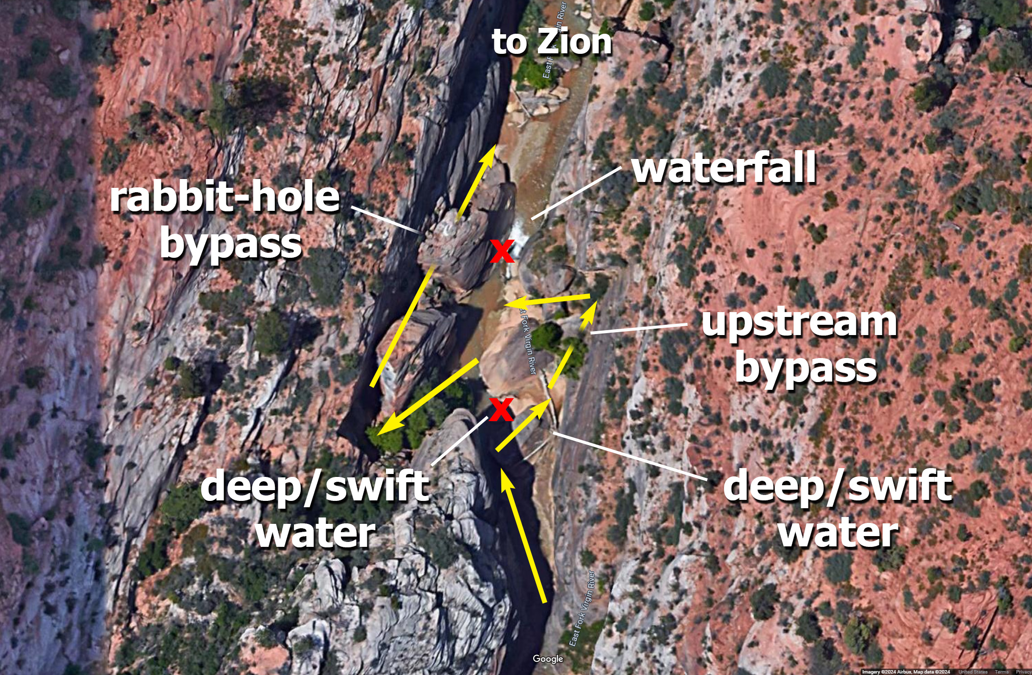

Now at the waterfall — at times it’s possible to carefully climb up/down the boulders and logs on the side of the waterfall and wade through a likely chest-deep pool below. However, at other times water has been known to be rushing over the entire obstacle and/or the logs to be unstable. Luckily there is a cave-like bypass route which can also be used. Read more about this in the Barracks Obstacle Bypass or watch a video about it. One good thing about the obstacle — it stops the cows from going any farther down the canyon!

May 2009
Below the obstacle is another stretch of gorgeous canyon before another small canyon enters on the right with a small waterfall which often makes a pool at the very bottom. This is Misery Canyon and it’s possible (though difficult) to climb up into the lower section of this slot canyon. To see all of the amazing narrows though, one needs rappelling gear and to start at the top to do the full Fat Man’s Misery technical route.
The Hayduke Trail climbs out of The Barracks via a very steep gully immediately downstream from this point. However, continuing down canyon to the next exit is a better option. It’s a little bit longer, but the exit is not quite as steep there and it takes one through arguably the best parts of the canyon. I will refer to this as the “Alternate Route”, but really it is the main route for all but the Hayduke Hikers.
 Continuing down canyon one will almost immediately enter a great set of narrows. This is the narrowest section of The Barracks and at times the light through this section can be stunning.
Below the narrows the canyon opens up a bit and a spring bubbles up on the left. Watch out for quicksand in this section. The next few hundred meters is a gorgeous section where the wider walls allow enough sunlight in to give life to moss, flowers, and small trees alongside the river. Soon one will see the bench on the right which is the alternate exit route and way up.
BUT… before climbing up, drop your bag and explore a little more down river.
Immediately downstream from the exit route is the Powell Plaque commemorating John Wesley Powell and his team who first explored this canyon in 1872. The plaque is on the same side of the canyon as the exit route and tells how Powell gave it the name Parunuweap Canyon from the Paiute Indians meaning ‘Roaring Water Canyon’.

Continuing downstream one passes the boundary of Zion National Park. Then the canyon constricts again into another spectacular set of narrows.


The canyon continues to be very scenic until a group of boulders blocks easy progress down the canyon. Ropes and/or climbing skills are needed to continue down past this point and around the bend to where one can get a glimpse of the top of Labyrinth Falls. This is as far as one can go (not only safely, but due to park restrictions as well.) Turn around and head back up canyon.
The Barracks Exit: Climb out to Checkerboard Mesa
Back at the exit route climb up onto the bench mentioned earlier. From there the route climbs abruptly up along a gully of stable, but sharp rocks. Though there isn’t really any exposure, a tumble here would be painful! Take your bag off if you feel the need for more caution.

climb out route (an alternate vs the official Hayduke route.)
At the top of the gully it flattens out and one soon intersects again with the Hayduke Route. From here one needs to get to the ridge to the north. Head north across slickrock and then up another gully to get to the ridge.

Follow the ridge north toward the white cliffs and then up on the slickrock to contour west around the “backside” of Checkerboard Mesa.

back of Checkerboard Mesa
Follow the use trail which goes on the west side of Checkerboard Mesa. It might be semi-brushy as it goes up and over the saddle before dropping down into the East Canyon of Zion and intersecting the park road. The parking area for Checkerboard Mesa and the east park entrance is just a short ways up the road to the right.
Full Gallery:
-

- general map
-

- upper Barracks
-

- upper Barracks
-

- Mineral Gulch Narrows | The Barracks ⮞⮞⮞
-

- Mineral Gulch Narrows
-

- Mineral Gulch Caves
-

- Cows above Mineral Gulch
-

- Petroglyphs near Rock Canyon
-

- The Barracks
-

- The Barracks
-

- French Canyon — scenic side canyon
-

- the slot | Poverty Wash ⮞⮞⮞
-

- Poverty Wash Narrows
-

- Poverty Wash
-

- The Barracks

-

- looking down from upstream bypass
-

- Obstacle and Bypass 2015
-

- May 2009
-

- Bottom of Misery Canyon
-

- Official Hayduke Route
-

- Narrows downstream from Misery Cyn
-

- Bubbly Spring
-

- Open Section of Canyon
-

- Junction with Exit Route
-

- Powell Plaque
-

- Below Powell Plaque
-

- Lower Canyon Narrows
-

- Lower Canyon
-

- the lower route up and out
-

- Looking down Alt Route
-

- Route up from nice camp area
-

- Looking down on nice camp area and route choice
-

- detail map — dashed route recommended
-

- Camp above the Barracks
-

- back of Checkerboard Mesa
Discover more from Across Utah!
Subscribe to get the latest posts sent to your email.


Pingback: The Barracks Obstacle – Across Utah!
How far down Poverty Wash was the picture take of Poverty Slot?
Not sure how far DOWN, but as stated it’s about 20 minutes from the bottom of Poverty up to the narrows (which are very short in length). Follow the “Poverty Wash Diversion” link on this page to read more about the side hike from the Barracks (I’ve never done it form the top.)
Wondering what gage you use to judge the water flow. I was told to use this one https://waterdata.usgs.gov/nwis/uv?agency_code=USGS&site_no=09404900 and am wondering what would be a safe CFS flow. Great write up!
That one should work, or the one upstream at Glendale. I can’t say for sure, but I’m guessing a good rule of thumb would be comparable to the Narrows and anything over 100cfs could be dangerous. I don’t think the East Fork commonly gets to that point based on spring run-off alone though.
This is such a great guide… thank you! One question though…. with the Narrows you need a pretty sturdy pole to get down the river. Would a pole like that be useful or not-so-useful for this hike?
Yes — it would be very helpful in my opinion. The river portion of The Barracks is very similar to the Narrows, but the hike as a whole takes a bit more work to get there (and back) via a off-trail route which can be exhausting on a hot day.
Thanks! I was thinking of taking my trekking poles but thanks for letting me know I should take a big sturdy stick instead!! Very helpful
Actually — trekking poles would work fine as well (that’s what I use.) I just meant that it would be helpful to have SOMETHING to help test water and keep your balance.
Thanks for the clarification and the tips!
If I had a chance to do Coyote Gulch or the Barracks, which hike would you suggest I do?
Love your blogs, video, pictures etc.
Thanks!
Heya Cindy — that’s a tough choice as they are both really amazing, but quite different. Coyote Gulch might be more spectacular over-all with MORE to see, but… it is also MUCH more popular and thus crowded at times. The season might play a factor as well — the Barracks is better IMHO in the warmer months, whereas Coyote Gulch is best in the Spring/Fall.
I’m planning a backpack trip with my son the week after next to the Barracks, following EF Virgin River from Mt Carmel to Checkerboard Mesa. I was told there are often log jams and that with the heavy rains this summer that there may be areas where we will get into some chest deep water. I wanted to see if anyone has been there recently or knows any utah backpacking forums online where I can post this question. I’m going with my 12 year old son and flying in from Oregon on Oct 14, 2021. Thanks, Jeff
I only have hiked it in the spring, but I really doubt the logjams would ever get bad enough to prevent travel up or down the canyon as there are only a few true chokepoints and they each have methods of bypass. Also, the deepest “mandatory” water will likely only be about 3′ deep. BUT… it is ideal to get the latest conditions before setting out. My site doesn’t get that type of frequent traffic — but you might try Backcountrypost dot com or the GSENM Group on Facebook. Good luck and have fun!
Hi Jamal, I wasn’t expecting a reply since the last posts on this forum were from 2019. I’m so happy to be wrong. Thanks for the details and for the links to the Facebook group and other site. I’ll post on those to see if anyone may have the latest conditions at Parunweap Canyon.
Jeff
Hey Jamal, great report. I will be there in May and would like to know if you can do the route the other way around and not go all the way. Thanks!!
Yes — in fact, that’s the only way I’ve done it as I always start in Zion and head upriver. It’s very possible to do an out-and-back and only see the lower end of the canyon. This could be done as a day-hike, but it would me more enjoyable to spend at least one night in (or close to) the canyon.
Thank you!!! I will write an email to you with some more questions :-).
Jamal, thank you for all of your useful information. If you hiked in from Checkerboard, how far upstream would you have to go to find a good campsite? I have also thought of hiking in from Meadow/Mineral and exiting checkerboard, but am not sure if that would be doable in two days. It would make the shuttle shorter though.
Sorry for slow reply — I’ve been out hiking! The best camp sites in the lower end are actually above the river on the bench. I camped right beside the river by the exit route last time and it was fine, but fairly small. Offhand I cannot think of any potential sites below the Boulder Obstacle, but there area some above at “Big Red Bend” or near Poverty Wash.
Hi Jamal, we just found your site through your youtube video Across Utah 2015 …great stuff and thanks for the website its a wealth of info. Our question is what is the ideal time of year to do the Barracks area?
Much Thanks Dean …
I’ve only been there in the spring, but I love it that time of year. Early summer would probably be nice as one can cool down in the water — but watch out when monsoon season rolls in. I bet the fall is gorgeous with the colors. So… anytime except for winter?!
Another great report thanks!
We hiked all the way down from Mt Carmel junction and out to Checkerboard mesa in spring 2014 over a day and a half and saw no one until near the road at Checkerboard. One of the most beautiful hikes anywhere! Kelsey calls the upper part of the canyon ‘uninteresting’ but for us it provided a mellow, lovely approach before the excitement of the canyon narrows. We also enjoyed a couple of the side canyons.
I like the sound of the alt exit from the Barracks and the chance to explore a bit more. Must return soon!
Brian
Impressive. Thanks for sharing your adventures.