


– Middle of Hatch Point Mesa –
![]()
The Over Hatch Point Mesa Route is a great short-cut for connecting Kane Springs Canyon and Lockhart Basin. The route saves about 12-15 miles when compared to the more circuitous Lockhart Backcountry Road and/or the Hayduke Trail. It also offers great views of canyon country and the La Sals and has a public campground at its mid-point with running water (BLM states potable water no longer available), trashcans and a pit toilet. In order to complete the route, one must be comfortable scrambling up or down a massive talus slope and boulder gully on the western side of the mesa overlooking Lockhart Basin.
Here is the the description headed S/SE or from Kane Springs Canyon to Lockhart Basin.
The route begins off the Kane Springs Road approximate 4 miles south of the turn off turn-off to Hurrah Pass. Kane Springs Creek is likely to be flowing in this section, though mostly obscured from the road. One will see Trough Springs Canyon open up on the opposite side of the canyon from the road — that will be the route up. As the road goes up and over a small hill, look for petroglyphs on a large boulder by the road. Then, begin looking for a way through the thick brush, across the creek, and up into Trough Springs Canyon. Near the junction of the two canyons it is extremely brushy and thus it might be necessary to follow the road a bit farther until one finds a break and then double back.

Once up into Trough Springs Canyon travel will be much faster. The bottom part of the canyon is likely to be dry, but within about 1/2 mile one should begin to see water and then soon a nice creek will form.
In about another 1/2 mile look for a loosely cairned route climbing up the side crack/canyon on the right. This is the official, but not frequently traveled, Trough Springs Canyon Trail. The main canyon will continue to be nice up from this point, but there are reportedly no other routes out of the canyon.
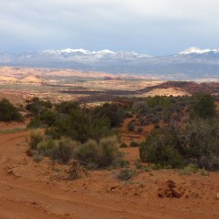
The route climbs steeply up and soon behind you one will see the La Sal Mountains peeking out above the Behind the Rocks area.

Once the route tops out of the steep side canyon, it doubles back closer to the rim of the main canyon and then follows a fairly well-worn path gradually upward before arriving at the TH area in about 1.75 miles.
From the parking area follow the dirt road up to a split. The more-traveled route will go to the right to connect to the main road headed out to the Anticline Overlook. But, instead go left and follow the backroad toward Hatch Point Campground. There might be several spur roads in the area, so have a map handy to make sure you are headed in the right direction (ie toward the high point to the south.) The campground area is actually fenced off and one will need to pass it and then double-back in order to easily visit. It’s likely worth a stop though with running water (BLM states potable water no longer available), pit toilets, and trash collection. The views from the campground are great looking out over the meadow below and on to the Behind the Rocks area in the distance.
NOTE: early-spring travelers should be aware that a hiker reported that the campground water was OFF on 4/22/2017. However, it’s always been ON for my visits in May. As of 2023 the BLM website states that potable water is no longer available at the camp area.
.
Leaving the campground one quickly intersects the main road. Walk down this for about a mile where you will want to angle off road to the right in order to enter a gully which will soon intersect a jeep road. Note: some older maps show this area as private property, but I’ve never seen it posted in my travels through the area. If in doubt, just continue a little farther down and pick up the Jeep road on the right where it leaves the the main road.
Once on the Jeep road the route can be seen headed out toward the edge of the plateau in the distance.

Along this section, the canyon system to the right is inviting with numerous sandstone domes and an inner canyon which dramatically drops away. The closest drainage is likely to have water in it as well. Instead of taking the easy road (the Jeep route), one can access the water in the stream below and then take what I call the “Rim Route” contouring the side canyon toward the edge of the mesa and then re-connect with the Jeep road at its end. This is the most scenic route, but it’s definitely a little bit slower. It also may be possible to descend this side canyon to Lockhart Basin directly, but the upper section is tough and I have yet to confirm a a route safely goes to the bottom. Even if it did, it would mean missing the incredible views along the Rim Route and from the edge of the mesa, so you may not want to give that up.

along the “Rim Route”
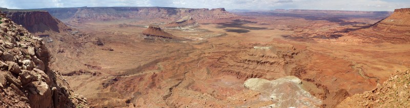
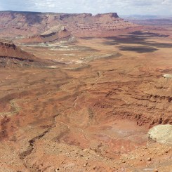
Whether you follow the Jeep road or take the Rim Route, soon you will be at the edge of the mesa enjoying an incredible view of Lockhart Basin and over Canyonlands with Junction Butte and Island in the Sky visible in the distance.
One’s exuberance for the great view might quickly be tempered by the realization one now needs to climb down from this point! I dubbed it “The Striped Monster” during my first ascent due to the colorful rock layers… and the fact that it was a monster to climb! Here’s the view looking down:

Take your time and slowly work your way down finding the easiest, most stable route as you go. The upper section is the most difficult.
NOTE: climbing up/down such rocky slopes can be very dangerous. Take extreme caution to not dislodge any rocks as a rockslide could result endangering you and anyone below. Even some of the large boulders here are only loosely held in place.
.
Once down, turn around and marvel at what you’ve just descended.

Continuing on… one can quickly pick up a Jeep road that heads N toward the junction of the Lockhart Backroad very near where the Hayduke Trail comes up Lockhart Canyon and thus completing this route. Haydukers will want to continue on to Rustler and Indian Creek Canyons.
Gallery:
-

- area map
-

- petroglyphs by road near start of route
-

- Kane Springs Creek
-

- Bottom of Trough Springs Canyon
-
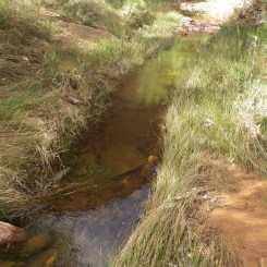
- flowing stream in Trough Springs Canyon
-

- looking back over Kane Springs Canyon to the La Sals
-

- looking down steep climb
-

- near the Trough Springs Canyon TH
-
- road headed to TSC trailhead
-

- looking across mesa toward Behind the Rocks
-
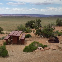
- Hatch Point Campground
-

- water, trash and toilets
-

- the main road on the mesa
-

- Jeep road headed toward edge of mesa
-

- canyon system north of Jeep road
-

- The Rim Route
-
- stitched panorama of Lockhart Basin
-

- edge of the mesa
-

- looking toward Island in the Sky
-

- Looking down the Striped Monster route (go to the far right here)
-

- looking back up at a difficult section
-

- Lockhart Basin from about 1/2 way down
-

- looking back at descent/ascent route
-

- “Striped Monster” Descent/Ascent Route
See Also:

Video Segment Hiking Route in 2013 (Reverse Direction)


Great ideas as always! FWIW, I found the water off in the Hatch Point campground in late October as well back in 2017.
Trough springs is one of our favorite local hikes. 🙂
Good to know — sounds like the campground might not be a reliable water source in the shoulder season. I’d like to get back to Trough Springs Canyon myself; maybe explore up the canyon above where the trail exits.