


– part of the Hayduke Reference –
I’m not a big fan of the ‘by-the-book’ Hayduke route from Moab to Lockhart Basin. Maybe it’s because I had a miserable time 2 of the 3 years I’ve walked along the section. It might have been my 2009 experience when I found the springs in northern Lockhart Canyon dry and ended up going a long way without any water OR maybe it was almost getting blown off the road by numerous 4-wheelers en route to Hurrah Pass OR just how walking along pavement in general makes me antsy. It’s definitely a scenic area and definitely the most easily followed route , but I think I’d usually opt for the Behind the Rocks or Over Hatch Mesa alternates for this section personally. Here’s my overview of the section:
Leaving Moab the route follows the paved Kane Creek Blvd along the Colorado River. The road is seen here from up on the Moab Rim Trail:  Farther along a popular stopping point for day-trippers from Moab is Moon Flower Canyon. It’s worth a stop to join the crowd and check out the petroglyphs here. There are more unmarked petroglyphs along the road so keep an eye out. Just past Pritchett Canyon, the road soon turns to gravel as the it follows Kane Springs Canyon up away from the river. As the road climbs high above the inner canyon, look for big boulders on the right down a small incline which are covered with petroglyphs. The famous ‘Birthing Scene’ petroglyph panel is here. A side hike leaves on the opposite of road nearby as well to climb up to Funnel Arch (aka Cable Arch.)
  Past the switchbacks and before the bottom of a side canyon there is a small “squirter” spring which provides great water. One might find water in Hunters Canyon just ahead, but otherwise this spring is likely to be the last good water for a ways. Hunters Arch is about 1/2 mile up Hunters Canyon if one wants to opt for a diversion.

Devils Golf Ball
Farther up the road the canyon opens up substantially. There are several spur roads in this section, but it’s easy to stay on the main road. Watch for more boulders with petroglyphs along the left side of the road. Near the camping areas the Happy Turk Hoodoo (aka Devils Golf Ball) is also just off the road on the left and is a mandatory quick diversion to stand under it.
Soon one will come to a junction where the Kane Springs Canyon Jeep road goes left and the Hayduke continues along the road toward Hurrah Pass to the right.

junction to Hurrah Pass
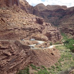
The climb up to Hurrah Pass provides great views back down on Kane Springs Canyon and it’s possible to observe the localized anticline geology aka the bending of the earth.

looking down Kane Springs Canyon
Once at the pass one can get a glimpse of the Potash evaporation ponds on the other side of the river. Descending the west side of from Hurrah Pass one passes several interesting hoodoos and side canyons before getting back down in the flats. Soon a spur road on the right leads through a Frisbee golf course and to Basecamp Adventure Lodge. Its owner Tom is very backpacker-friendly and will likely offer up a cold drink if desired. Continuing along the route soon nears the Colorado and then parallels it on a bench. This next stretch is fairly dry with little shade, but access to the river is possible in a few spots if one needs relief. Also, just before coming to the split in the road at Chickens Corners, look for a grassy stock pond on the left which is another good source for water.
Once at the split in the road the Hayduke continues to the left along the Lockhart Backcountry Jeep Road. The rough side canyon climb is the most difficult section for vehicles along the entire backroad. Many unofficial online “Hayduke” maps show incorrect routes through this area. Evidently several “cowboy” routes climb to the top of the canyon system, but if you want to stay “Hayduke Official” stick to the road (though it’s very circuitous, so a shortcut route might be in order!)
Atop the canyon the route winds past some more interesting hoodoos while making a long and winding way around the northern point of Hatch Mesa. Canyonlands Overlook (and UN Tablet) tower above this spot and Dead Horse Point can be seen across the river to the north.

looking across to Dead Horse Point
Soon one needs to leave the road and enter the upper NE branch of Lockhart Canyon. There are ways to short-cut this route some (see interactive map), but they will require some minor scrambling. Also, if there is water to be found here (none in 2009), it will likely be in the upper reaches of the canyon.
Headed down canyon one eventually comes to a large dryfall. Bypass on the left and follow the rim of the canyon down and to the south. Eventually you will come to a side canyon where a constructed cattle trail provides access down into the canyon. Headed down this side canyon, a side-side canyon on the right has piped waterworks for water (also dry in 2009, but good in 2018). Not much farther one intersects main Lockhart Canyon. One can turn right and go to the Colorado River if in need of water, or turn left and continue on the route up canyon.
The upper part of the southern branch the canyon has a sandy road running through it. In the last portion one it likely to see an outbreak of water from the spring marked on the map — but the water can contain high levels magnesium sulfate so it’s pretty bad to drink. There’s also a rancher line-shack in the area with a water catchment system on the rock bench above which may or may not hold water depending on the season.

Upper (southern) portion of Lockhart Canyon
NOTE: it was in a side drainage in this area that the “Utah Monolith” was found in 2020. I was one of the first people online to ID the location based on the regional geology and the use of Google Earth #HumbleBrag. It has since been removed. 👍

A little bit farther and one will emerge from the canyon and see the wide-open Lockhart Basin ahead. Almost immediately one comes to the intersection and re-connects with the Lockhart Backcountry Road. Go right and head towards Rustler Canyon. There is likely to be a large cow reservoir just west of this location along the road, though its quality can be questionable.
From here the Hayduke continues to follow the road for about 3-4 miles before it’s time to leave it behind and drop down into the upper reaches of Rustler Canyon.
Gallery:
-

- Paved Road Portion (as seen from Moab Rim Trail)
-
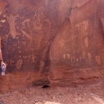
- Birthing Scene Petroglyphs
-
- The Switchback
-

- Spring near Hunters Canyon
-

- crowds at a climbing wall
-

- petroglyphs in Kane Springs Canyon
-

- junction to Hurrah Pass
-

- looking back up Kane Springs Canyon
-

- looking down Kane Springs Canyon
-

- rock fortress near Hurrah Pass
-

- Hurrah Pass
-

- hoodoo near Hurrah pass
-

- side canyon near Hurrah Pass
-

- along the Colorado River
-

- Jeep road climbing up side canyon
-

- more towering hoodoos
-

- looking across to Dead Horse Point
-

- Looking up to Canyonlands Overlook Point
-

- Looking down into Lockhart Canyon
-

- Upper (southern) portion of Lockhart Canyon


Thanks Jamal for pointing out the seep in the side canyon of the side canyon just after descending from the shelf above Lockhart canyon into it. Even in bone-dry 2021 it provided a gallon in about 15 min. Clearly had some mineral content, but really good palatability. The hike down to the Colorado through DEEP sand did not look at all attractive.
Heartily agree about the misery of Lockhart. Behind the rocks/Hatch mesa is the way to go, even if the middle section of the striped monster scared the shit out of me two years ago. Having seen it from below now, I would know how to get down it without running afoul of the cliffs at the bottom.