


– amazing sandstone colors at Yellow Rock –
![]()
approx 3 miles round-trip
Yellow Rock is an interesting geologic formation that sits atop the reef called the Cockscomb in the southern portion of Grand Staircase/Escalante National Monument. Though there is no official trail, a fairly-well-worn route zig-zags about a mile up a gully to the massive outcrop of sandstone. The route starts at the Hackberry Canyon TH where one will likely find ample parking. Most drive here via Cottonwood Road, but others may be on longer hikes such as a big loop in the Upper Paria or possibly the Hayduke Trail.
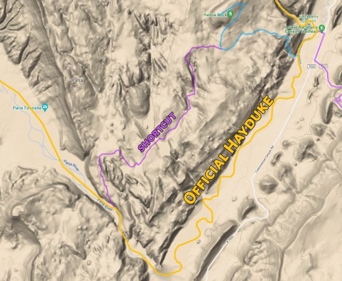
Note: if connecting to/from the Paria, consider the cool shortcut route through the “Valley of Color” south of Yellow Rock. See Master Map for route.
To get up to Yellow Rock from the TH don’t head up into Hackberry Canyon (though it’s worth a side visit if time allows), instead follow Cottonwood Wash downstream just a short distance until you see the gully enter on your right. Follow this side wash up a ways before picking up a route up through the rocky slope on the right. After a good climb, the route somewhat flattens and various routes may emerge as Yellow Rock comes into view. There is really no ‘wrong’ way here, but the best views are likely to be found on the southern end of the outcrop where the colors are the most vivid and nice streaks of orange and white intermix with the yellow. Ambitious hikers can climb all the way to the summit for incredible views in every direction.

One can turn around and return the same way, or if feeling a bit more adventurous, return down the alternate rock gully to the south. This route is shorter, but definitely not as well traveled and much rougher.
If wanting to explore more (or doing a thru-hike), it’s possible to continue past Yellow Rock and pick up a trail. The trail will split and the left-hand route runs south and will take one to point where it’s possible to access the Paria River near where it cuts through the Cockscomb at ‘The Box’. A side trip here will also lead one to the interesting rock formation known as Red Top. Back at the junction, the other direction will lead up through cow pastures and eventually to the area near Pollock Arch and on toward Hogeye Canyon.
For a different perspective of Yellow Rock (and the entire area), one can drive (or walk) up the Brigham Plains Road which climbs up the cliffband to the east of the trailhead. The road can be really rough at times, especially the upper portions. But, it rewards those who make it with an outstanding view of Yellow Rock and the entire Cockscomb formation.

view from top of Brigham Plains Road. Mollies Nipple, Yellow Rock, Hackberry Canyon
High-res Gallery:
-

- Yellow Rock peeks out from below
-

- Approaching the formation
-

- Yellow Rock and its amazing color
-

- Yellow Rock’s massive size
-

- amazing sandstone | Yellow Rock ⮞⮞⮞
-

- Yellow Rock and Mollies Nipple
-

- Cockscomb View while going up Brigham Plains Road
-
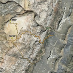
- Yellow Rock Area Map
Discover more from Across Utah!
Subscribe to get the latest posts sent to your email.


Thanks for the map Jamal – I am finally getting back to Cottonwood Canyon rd next week to hike this beauty!
Hope you had a great trip. ✌
OMG. What a ride!!! My wife and I just did the shortcut as the finish of the Paria-Hogeye-StoneDonkey-Hackberry loop. Absolutely mind boggling scenery. I did not really study the shortcut route in advance since doing it was kind of a game time decision. Just more or less followed the track log that Jamal provided. I did not anticipate the number of ups and downs and tricky terrain. I should point out that it took us 5 hours (maybe 4 without stops) to go from the hackberry/cottonwood confluence back to the Paria box trailhead using this route. It’s challenging. I would not recommend trying it without getting the track log from Jamal or leaving yourself a LOT of time for route finding.
Jamal, to be clear, is the purple route on you map above (s of yellow rock) the “valley of color” or do I need to go back and do the valley of color?
Thanks so much.
Awesome — glad you had a good hike. It really is some incredible and colorful geology in that area. And yes, the purple line goes down through what I referred to as “Valley of Color” — basically just a great gulley running from Yellow Rock down to Red Top. You are correct it’s not easy. In fact I probably shouldn’t call that route a “short-cut” as it would definitely take longer than the not-as-exciting route around down in the flats. Cheers!
Hey Jamal, thanks for the hiking guide for this. I used it to visit Yellow Rock last week! Your photos definitely show all the neat characteristics of that rock!