UPDATE: The page below was published as I was getting ready to set out on my hike across southern Utah in April of 2009. Since then, I've returned many times to refine the suggested route across the state and collect more detail on options.
See all the latest additions via Route Information on the new site.
Otherwise, let's go back to 2009...
The Plan
Though not officially one of my CurbPavement projects, the route will travel across several long stretches w/o crossing any paved roads. The route is my own creation made by stitching together official trails, documented x-country routes, 4x4 tracks, old mining roads and some pure cross-country stretches where the map will be the only guide. The route stretches across the southern part of the state from west to east and will travel almost entirely through public lands including through or near 5 National Parks, 1 National Monument, 1 National Recreation Area and 2 National Forests. The hike can be generally broken down into the following sections:
Western Utah and Pine Valley Wilderness
I will begin at the state line near the city of Uvada. Get it? Utah + Nevada = Uvada. From there I will travel through the Dixie National Forest and wind my way up through the Pine Valley Mountains. My route will greatly depend on the amount of snow still remaining at the end of April. If all goes well from the summit I should enjoy great views stretching to the east and across the entire next section of my hike.
Zion Country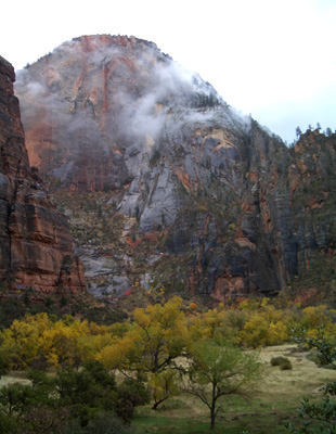
The second section of the my journey will take me from one end of Zion National Park to the other and up the Grand Staircase of White Cliffs to the east. I will begin in the Kolob Canyons section of Zion and as long as the snow isn't too deep travel up and over the West Rim. I will descend into Zion Canyon just temporarily before climbing out the other side to the East Rim. I will then continue down to the the East Fork of the Virgin and through the narrows of The Barracks as I exit the park. As long as water levels aren't too high, I will follow the river up to the White Cliffs east of Zion and on towards Bryce Canyon National Park.
Paria River and its Tributaries
Entering Grand Staircase Escalante National Monument, I will find my way to the Paria River and explore the many scenic side canyons along the way. Many of these canyons are incredibly narrow slot canyons; others contain evidence of a civilization long since gone. I will leave the Paria and head cross-country to Hackberry Canyon where I will head upstream through another slot canyon and to Grosvenor Arch where I hope to have one of my nine re-supply caches.
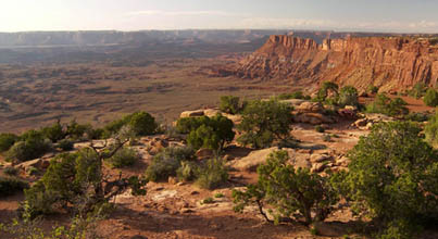
The Kaiparowits Plateau
The next section will be one of the most desolate of my trip. Though only 3-4 days in length, I'm likely not to see another soul as I cross the immense plateau rationing my water as I go.
The Escalante Canyons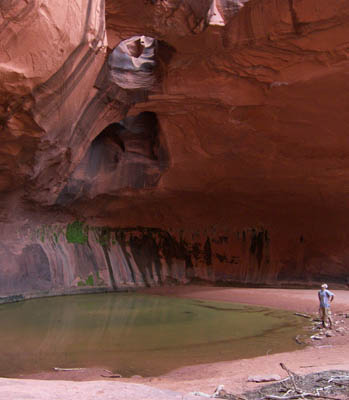
Approximately 4 weeks into my trek I will enter the canyons of the Escalante. If all goes well several of my friends from LA will meet me for part of this 5-day stretch which will wind its way through the scenic, red-rock canyons of the region. A portion of this section will be the same as my 2006 trek-- but it was such a nice section it's worth repeating.
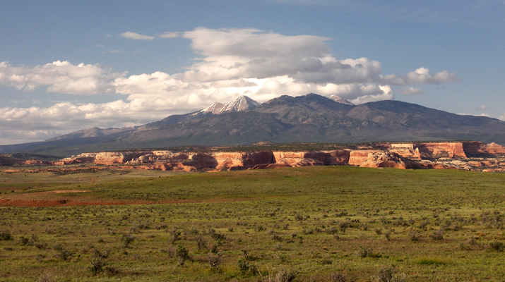
The Waterpocket Fold and The Henry Mountains
After a short cross-country section I will leave the Escalante behind and make my way to the Waterpocket Fold in Capitol Reef National Park. I will go up the narrow and twisting Lower Muley Twist Canyon. The canyon got the name by early pioneers who said the canyon was twisty enough to twist a mule! After a few days I plan to go up and over the last mountain range to be named in the United States-- the Henry Mountains. Snow-levels permitting, I hope to summit the highest of the 11,000+ foot peaks. In addition to great vistas over the surrounding desert, the Henry Mountains are also known for being home to one of the last remaining free-range bison herds in America.
The Dirty Devil and Happy Canyon
After descending the eastern slopes of the Henrys, I will make my way through Poison Creek Canyon and to the Dirty Devil River. Sounds inviting, no? Actually though extremely remote, it's a highly scenic area which I've never visited so I'm very excited to include it on this trek. Crossing the Dirty Devil River at this time of year should be fairly easy barring any recent storms. From there I will make my way up the more-friendly-sounding Happy Canyon and toward Canyonlands National Park.
Canyonlands: Lands End and The Fins
Another region I've never visited is the southern section of The Maze district in Canyonlands. After climbing down from Lands End on an official trail, I will make my way along an established back-country route through an area known as The Fins and up to The Land of Standing Rocks-- the area which served as backdrop to the finale in Edward Abbey's The Monkey Wrench Gang. I will continue through the Dollhouse region down to the Colorado River where I will borrow a ride across the river at the popular stopping point for those floating the river.
 Canyonlands: The Confluence to Behind the Rocks
Once across the mighty Colorado I will climb out the tall cliffs on the east side. I'm excited to see the Confluence-- the overlook of the Green and Colorado Rivers. I'd hoped to see this on my 2007 trek, but had to bypass it to shorten the length of that trip. From here I will travel out the eastern side of the park and into the Indian Creek Wilderness area. I plan on following the Hayduke trail for this section of my trek all the way to the Behind the Rocks region just west of Moab. As long as the early June temps are not too hot I hope to do some exploration in this scenic area as I approach Hwy 191 and the final section of my hike.
The La Sal Mountain to the State Line
The final section of my journey across the state will go up and over the highest peaks in southern Utah-- the La Sal Mountains. They should offer a welcome relief from the hot temperature below. In fact, they may be too cold as the mid-June conditions might still involve quite a bit of travel through snow. Conditions permitting I will summit the two highest peaks before beginning my descent down the eastern slopes and to the Utah/Colorado state line-- finally Across UT in approximately 600 miles and 49 days!
all content (c) 2009 by Jamal Green unless noted